History of SoHo
exerpted from: SoHo A Guide by Helene Zucker Seeman and Alanna Siegfried1600 | 1700 | 1800 | 1900 | 2000
Published by Neal-Schuman Publishers, Inc., New York, NY Copyright 1978
Bordellos | Cast Iron | SoHo Farm
"To understand fully present-day SoHo, it is helpful to imagine the past and to picture the farms, theaters, and hotels that once existed here. Manhattan in the 1600s was covered with grassy hills, streams, meadows, forests, and marshes. Trails through this wilderness connected six Indian villages that had settled here: Warpoes, Nahtouk, Ispetenga, Sappokanican, Muscoota, and Sherakopak. Presentday Broadway was then known as the Weckquaesgeck Trail.
A Dutch settlement confined itself to the southern tip of Manhattan. The earliest known survey of the Island, the Manatus Map of 1639, shows plantations, roads, and buildings already constructed by these Dutch settlers. Augustus Herrman, a Dutchman, bought extensive tracts of land during the 1660s, and a large portion was within the present day SoHo district. When he died, his brother-in-law, Nicholas Bayard, inherited the property and consequently became the largest land owner in Manhattan.
By 1728, a James Lyne map shows the area subdivided into sprawling farms. Broome Street, between Thompson and Greene Streets, was covered with trees and Beekman's Swamp encompassed Spring, Broome,and Grand Streets. West of Broome Street stood Bayard's Mount, the highest point in Manhattan.
Natural boundaries, such as Collect Pond and Lispenard's Meadow (in the area of present-day Lispenard Street) restricted travel northward. Settlement did not occur in the SoHo area until after 1775, when Broadway was extended north of Canal Street by the Dutch. The Collect Pond and Lispenard Meadow became country retreats for these early settlers.
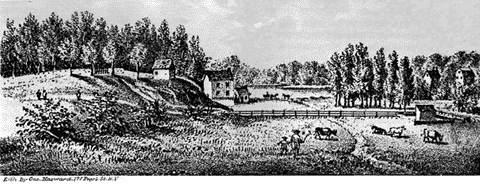
LISPENARD'S MEADOWS
Taken from the N.E. corner of the present Broadway & Spring St.
Drawn by A. Anderson, 1785
By 1767, large farms were being divided into smaller units, as indicated on
the Ratzer Map of New York City. The Viele Map of 1865, which is still used
by civil engineers for excavation purposes, shows Manhattan little changed.
But eventually, the emerging urbanization did have an effect. Health hazards
were created by the polluted waters of Collect Pond, and Bayard's Mount was
leveled to fill both the pond and Lispenard's Meadow.
The early 1800s was an elegant period in SoHo's history. Principally residential, the neighborhood was first inhabited by the wealthy and soon after by the middle class. In due time, rapid development attracted many business enterprises. Hotels and theaters, elegant stores, stately mansions, minstrel halls, gambling casinos, and brothels sprang up along Broadway. This was the Fifth Avenue of the day. Horse drawn carriages lined with velvet seats made their way down cobblestone streets where gaslight street lamps illuminated the rich hues of taffeta evening dresses.
As the activity increased, smaller adjacent streets also began to develop. Bordellos were common in the area and the city's first red-light district was soon established. These houses of "ill repute" were often luxurious. Guidebooks told potential customers where to seek their pleasures. Particularly informative listings could be found in the Directory to the Seraglios in New York, published by A Free Loveyer, in 1859:
Miss Clara Gordon
No. 119 Mercer Street
"We cannot too highly recommend this house, the lady herself is a perfect Venus: beautiful, entertaining, and supremely seductive. Her aidesdecamp are really charming and irresistible, and altogether honest and honorable. Miss G. is a great belle, and her mansion is patronized by Southern merchants and planters principally. She is highly accomplished, skillful, and prudent, and sees her visitors are well entertained. Good wines of the most elaborate brands, constantly on hand, and in all, a finer resort cannot be found in the City."Mrs. Bailey
No. 76 Greene Street, below Spring
"This quiet and comfortable resort is situated very central, and within a few moments' walk of Broadway and the principal hotels... Gents must come well recommended or they won't get in. . . The hostess is an agreeable lady, indued with a tasteful mind. . . Her young ladies behave with much prudence and propriety..."
After the Civil War, easy splendor gave way to a faster pace of life. By the 1880s, million dollar textile industries had settled in the area. As the population centers shifted uptown, industry and commerce followed. Small firms, import/export houses, truckina companies, wholesale textile houses, the "rag trade," and inexpensive clothing outlets began to move in and have remained even to the present time. It was not until the 1950s that a new breed of settlers again filtered into the area‹creative, inspired, artistic individuals with an imaginative zest for living and an economic need for low rents.
In October 1962, the City Club of New York published a report on the city's underutilized commercial areas. It was called The Wastelands of New York City, and characterized SoHo as an enormous commercial slum. After this report, plans for the Lower Manhattan Expressway were revived by Highway Commissioner Robert Moses. The roadway would have cut directly through SoHo, driving merchants and artists out of the area, and indiscriminately demolishing many stunning examples of 19th century cast iron architecture. The purpose of the expressway was to facilitate the flow of east-west traffic by connecting Williamsburg and Manhattan Bridges with the Westside Highway and the Holland Tunnel. Proponents of the expressway, under the leadership of Moses, cited the area's depressed property values and vacant buildings as justification for their plan. Strong opposition emerged, led by urbanologist Jane Jacobs, and in 1968, the Board of Estimates rejected the proposal. SoHo was given a reprieve.
Once known as "The Valley" and "Hell's Hundred Acres," this area would in only five years be considered a landmark district.
Cast
Iron in SoHo
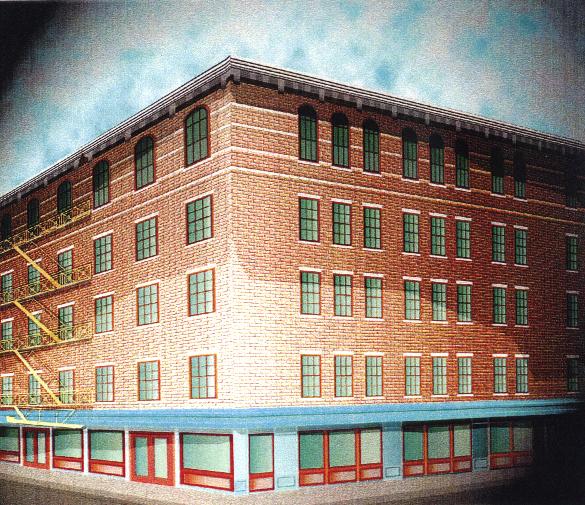
SoHo boasts the greatest collection of cast iron structures in the world.
Approximately 250 cast iron buildings stand in New York City and the majority
of them are in SoHo. Cast iron was initially used as a decorative front over
a pre-existing building. With the addition of modern, decorative facades,
older industrial buildings were able to attract new commercial clients. Most
of these facades were constructed during the period from 1840 to 1880. In
addition to revitalizing older structures, buildings in SoHo were later designed
to feature the cast iron.
An American architectural innovation, cast iron was cheaper to use for facades than materials such as stone or brick. Molds of ornamentation, prefabricated in foundries, were used interchangeably for many buildings, and a broken piece could be easily recast. The buildings could be erected quickly‹some were built in only four months' time. Despite the brief construction period, the quality of the cast iron designs was not sacrificed. Previously, bronze had been the metal most frequently used for architectural detail. Architects now found that the relatively inexpensive cast iron could form the most intricately designed patterns. Classical French and Italian architectural designs were often used as models for these facades. And because stone was the material associated with architectural masterpieces, cast iron, painted in neutral tints such as beige, was used to simulate stone.
There was a profusion of cast iron foundries in New York, including the major firms of Badger's Architectural Iron Works, James L. Jackson's Iron Works, and Cornell Iron Works.
Since the iron was pliable and easily molded, sumptuously curved window frames were created, and the strength of the metal allowed these frames considerable height. Thus, the once somber, gas-lit interiors of the industrial district were flooded with sunlight through the newly enlarged windows. The strength of the cast iron permitted high ceilings with sleek supporting columns, and interiors became more expansive and functional.
During cast iron's heyday, many
architects thought it to be structurally more sound than steel. It was also
thought that cast iron would be fire resistant, and facades were constructed
over many interiors built of wood and other inflammable materials. But, when
exposed to heat, cast iron buckled and later cracked under the cold water
used to extinguish fire. In 1899, a building code was passed mandating the
backing of cast iron fronts with masonry. Most of the buildings which stand
today are so constructed. It was the advent of steel as a major construction
material that brought a rapid end to the cast iron era."
In 1990, the Internet World Wide Web was established. Use of the interconnected graphical medium exploded, allowing people to interact, find information, view images and share discoveries on an unpresidented level.
In SoHo, Art NYC was begun to help the art community share its resources
with the rest of the world unfortunate enough not to live or work in New York.
Contact
us:
Ventilaire®
Realty Co.
PO Box 692
New York, New York 10013
fax 212-941-1796
email: rentals@canalspace.com